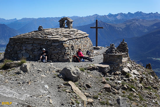
A hike over the artificial lake of Serre Ponçon to enjoy a panoramic view of Embrun, the turquoise waters of the lake, Savines Lake, Gap and hillsides, the Orres ski resort but also the Grand Morgon almost at hand. The summit hosts a massive stone chapel that seems to have been built to cope with the swiftest windstorms.
Mont Guillaume

The summit panorama is deserved after the 1200 meters of climb in front southeast. The departure takes place at an altitude of 1587 meters and the summit is 2545 meters above the sea level reference point defined by the Marseilles tide gauge.
Note that the IGN geoportal site shows 2545 meters above sea level, IGN 2542 m maps and the chapel sign indicates 2552 meters of altitude ... What is the exact altitude of the top of the bell tower of the chapel? Feel free to use the comments form at the bottom of this page, if you have tangible elements to know the answer ...
Plan at least 5 hours of walking; or ski if you practice cross-country skiing in sealskin, winter inevitably or in early spring.
The walk starts in the woods until you reach the chapel of Seyère, a place of passage during the pilgrimage from Embrun to Mont-Guillaume on the second Sunday of July. Larch trees then gradually give way to alpine meadows and rock gardens. Look well at the ground, you will, perhaps, to flush out a bunch of wild edelweiss not to pick especially. Génépi also abounds in the sector for lovers of strong alcohol, homemade ...
We recommend you, regarding the itinerary, the topo of the Ecrins National Park here http://rando.ecrins-parcnational.fr/fr/le-mont-guillaume
Panoramic megapixel view (UHD 1.16 gigapixels) from the Mont Guillaume
Zoom into the image to see more details
Fullscreen photo UHD https://www.ovalp.com/images/photos/hd/rando-mont-guillaume-o.html
The view from the summit of Mont Guillaume (Hautes Alpes) opens up more than 180 ° from the guillestrois on the left to the gapençais on the right. Facing you is easily distinguished the resort of Orres and the Grand Morgon overlooking the lake that can be seen all along its length to the dam of Serre Ponçon. We can see the summit of Mont Ventoux (1911m), Vaucluse, at the top right of the photo.


