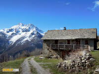
Vallouise France Hiking
-
Ibex of the Vercors
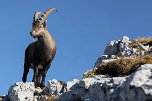
A beautiful walk in the Vercors to the summit of Grand Veymont at 2341 meters above sea level allowed us to observe and photograph many ibexes. We also offer a panoramic 360 ° photo from the summit of the Grand Veymont with a glimpse of Mont Blanc 150 km away but also views of the peaks of the Ecrins massif, more easily recognizable (Barre des Ecrins, Meije etc....).
-
Hiking at Mont Guillaume
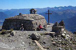
A hike over the artificial lake of Serre Ponçon to enjoy a panoramic view of Embrun, the turquoise waters of the lake, Savines Lake, Gap and hillsides, the Orres ski resort but also the Grand Morgon almost at hand. The summit hosts a massive stone chapel that seems to have been built to cope with the swiftest windstorms.
-
Resistance to the Maquis de Beassac and Célestin Freinet

Emmanuel Saint Fuscien (Doctor in Contemporary History and Lecturer at EHESS) devotes an interesting book to Freinet, under the title "A teatcher at war". Célestin Freinet, whose theses, in a few words, consist in putting the student at the center of learning, lived in Vallouise a few years at the end of the Second World War. His wife Elise Lagier Bruno being from the beautiful high alpine valley. He previously lived in the south of France, campaigned in the communist movement of the Alpes Maritimes and participated in the two world wars of the 20 th century.
-
Val d'Aoste

A long valley on the other side of Chamonix, just east of Mont Blanc enjoying an Italian Dolce Vita atmosphere. Many centers of interest and natural places more majestic than the others allow you to spend a relaxing or dynamic stay.
-
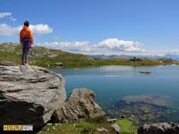
Hiking at the lakes Miroir and Sainte Anne

A beautiful loop starting from the Melezet (1692m) to the mirror lake (2215m) and then to Lake Sainte Anne (2407m) will offer you varied and wild landscapes alternating under woods and alpine pastures. It is possible to bivouac at the first lake taking care to protect from the cold and the... mosquitoes in the late summer.
-
Panorama Vallouise Ecrins from Oreac
We invite you to take a look at a 1732 million pixel (1.7 GB) megapixel HD panoramic picture representing the Vallouise valley and the Ecrins massif from the Oreac plateau above Puy Saint Vincent.
-
La Blanche
A nice hiking idea in the Vallouise valley is to leave the hamlet of Puy Aillaud (1580 meters above sea level), to reach the summit of Blanche (2953 meters above sea level) and its superb panorama towards the Pelvoux.
-
Chapel "Le Corbusier"
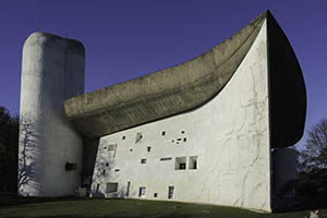
The Chapel Notre Dame du Haut on the hill of Bourlémont (commune of Ronchamp), in Burgundy Franche Comté, will offer you a moment of calm and relaxation; especially if you find the way to visit places outside school holiday periods or "big" religious celebrations.
-
Puy Aillaud lake
Lake Puy Aillaud (2534 meters) is accessible in about 2 to 4 hours, depending on your pace, from the hamlet (1600 m) of the same name. This lake rounded measuring about 60 meters in diameter.
-
Belvedere three refuges
The viewpoint of the three refuges (2350 meters) is located in the High Alps (Hautes Alpes, 05) in Pelvoux even if the start and most of the ride takes place in Vallouise. The lookout is located in the National Park Ecrins.
-
Cassis Creeks

30 minutes from Marseille, the creeks have a unique geographical feature in France at least to this extent.
The creeks are accessible only on foot, from Cassis and Marseille. -
Concert Nino Soardi
At the end of August a magical moment occurs at the edge of the Queyras (Hautes Alpes) and Piemont. A beautiful festival takes place at the small shelter Nino Soardi. A live band is playing for about an hour of popular tunes (film music, known jazz standard song etc...).
-
Flowers Bans valley walk

Bans valley is flooded by spring flowers! Located in the valley of Vallouise after locality of Entraygues towards the Bans refuge the valley is quite easily accessible, a first ascent leads to a ledge. Early in the season, many snowfields through the trail.
-
Col d'Anon hiking
The small collar Anon is located between the Fressinière and Fournel valley. Both overlooking the Durance valley in the area of L'Argentière-la-Bessée (South France).
Town and village of the Hautes Alpes (05)
Abriès - Agnières-en-Dévoluy - Aiguilles - Ancelle - Antonaves - L'Argentière-la-Bessée - Arvieux - Aspremont - Aspres-lès-Corps - Aspres-sur-Buëch - Avançon - Baratier - Barcillonnette - Barret-sur-Méouge - La Bâtie-Montsaléon - La Bâtie-Neuve - La Bâtie-Vieille - La Beaume - Bénévent-et-Charbillac - Le Bersac - Bréziers - Briançon - Bruis - Buissard - Ceillac - Cervières - Chabestan - Chabottes - Champcella - Champoléon - Chanousse - La Chapelle-en-Valgaudémar - Château-Ville-Vieille - Châteauneuf-d'Oze - Châteauneuf-de-Chabre - Châteauroux-les-Alpes - Châteauvieux - Chauffayer - Chorges - La Cluse - Les Costes - Crévoux - Crots - Embrun - Éourres - L'Épine - Esparron - Espinasses - Étoile-Saint-Cyrice - Eygliers - Eyguians - La Fare-en-Champsaur - La Faurie - Forest-Saint-Julien - Fouillouse - Freissinières - La Freissinouse - Furmeyer - Gap - Le Glaizil - La Grave - Guillestre - La Haute-Beaume - Les Infournas - Jarjayes - Lagrand - Laragne-Montéglin - Lardier-et-Valença - Laye - Lazer - Lettret - Manteyer - Méreuil - Molines-en-Queyras - Monêtier-Allemont - Le Monêtier-les-Bains - Mont-Dauphin - Montbrand - Montclus - Montgardin - Montgenèvre - Montjay - Montmaur - Montmorin - Montrond - La Motte-en-Champsaur - Moydans - Neffes - Névache - Nossage-et-Bénévent - Le Noyer - Orcières - Orpierre - Les Orres - Oze - Pelleautier - Pelvoux - La Piarre - Le Poët - Poligny - Prunières - Puy-Sanières - Puy-Saint-André - Puy-Saint-Eusèbe - Puy-Saint-Pierre - Puy-Saint-Vincent - Rabou - Rambaud - Réallon - Remollon - Réotier - Ribeyret - Ribiers - Risoul - Ristolas - La Roche-de-Rame - La Roche-des-Arnauds - Rochebrune - La Rochette - Rosans - Rousset - Le Saix - Saléon - Salérans - La Salle les Alpes - La Saulce - Le Sauze-du-Lac - Savines-le-Lac - Savournon - Serres - Sigottier - Sigoyer - Sorbiers - Saint-André-d'Embrun - Saint-André-de-Rosans - Saint-Apollinaire - Saint-Auban-d'Oze - Saint-Bonnet-en-Champsaur - Saint-Chaffrey - Saint-Clément-sur-Durance - Saint-Crépin - Saint-Disdier - Saint-Étienne-en-Dévoluy - Saint-Étienne-le-Laus - Saint-Eusèbe-en-Champsaur - Saint-Firmin - Saint-Genis - Saint-Jacques-en-Valgodemard - Saint-Jean-Saint-Nicolas - Saint-Julien-en-Beauchêne - Saint-Julien-en-Champsaur - Saint-Laurent-du-Cros - Saint-Léger-les-Mélèzes - Saint-Martin-de-Queyrières - Saint-Maurice-en-Valgodemard - Saint-Michel-de-Chaillol - Saint-Pierre-Avez - Saint-Pierre-d'Argençon - Saint-Sauveur - Saint-Véran - Sainte-Colombe - Sainte-Marie - Tallard - Théus - Trescléoux - Upaix - Val-des-Prés - Vallouise - Valserres - Vars - Ventavon - Veynes - Les Vigneaux - Villar-d'Arêne - Villar-Loubière - Villar-Saint-Pancrace - Vitrolles
Communauty of town and/or village in the Hautes Alpes (05)
Communauté de communes du Briançonnais (Briançon), de l'Embrunais (Embrun), du Pays des Écrins (L'Argentière-la-Bessée), de Tallard - Barcillonnette (Tallard), de la vallée de l'Avance (La Bâtie-Neuve), des Deux Buëch (Veynes), du Laragnais (Lazer), du Guillestrois (Guillestre), du Champsaur (Saint-Bonnet-en-Champsaur), de l'Escarton du Queyras (Aiguilles), du Serrois (Serres), interdépartementale des Baronnies (Lagrand), du Haut Champsaur (Saint-Jean-Saint-Nicolas), du canton de Ribiers Val de Méouge (Ribiers), Savinois - Serre Ponçon (Savines-le-Lac), du Haut Buëch (Aspres-sur-Buëch), du Pays de Serre Ponçon (Espinasses), du Valgaudémar (Saint-Firmin), de la Vallée de l'Oule (Bruis).