The Hautes-Alpes allow a multitude of outdoor activities, most often playful. Many professional activities also depend on the weather. We offer some online forecasting tools but also elements of understanding the top Alpine weather. Indications and information on the web will allow you to establish your own forecasts on the very short term.
Weather forecasts and observations in Hautes-Alpes (Alps)
Hiking, paragliding, climbing, mountaineering, rafting, kayaking, boating, kite surfing in summer; downhill skiing, cross-country skiing or hiking, ice waterfalls, snow kites in winter. The list could be extended without difficulty as the department of Hautes-Alpes is a paradise for all kinds of sports. The particularity of all these activities lies among other things in the importance of weather, an important variable, and sometimes even vital, in outdoor activities.

Local meteorological specificity
 The Hautes-Alpes enjoy a lot of sunshine, almost as much as Provence and the Côte d'Azur, a little further south and also in Provence Alpes Côte d'Azur (Paca).
Bad weather is often confined to the west and north of the Lautaret and Galibier passes in the north of the department. A small foehn effect then often protecting the northern Alps from the south drying out and warming the atmosphere.
Another local specificity lies in the east returns. The Italian depression of Piedmont or the Gulf of Genoa regularly sends back humid air on the massifs, accumulating the winter in strong snowfalls often more marked in border zone.
The mistral here more than elsewhere cleans the sky and twinkles the stars of its atmospheric turbulence.
The valley breezes finally, nocturnal or diurnal, incline the trees, for example in the Guillestrois as the valleys can be narrow and the summits high. Thermal inversions of radiation, advection or subsidence regularly discourage gliding and free-riding, but also snow-climbers cold-eagle along the ski slopes.
Weather forecast Hautes Alpes, Ecrins and Briançonnais (French Alps)
A turnkey foreclosure by Météoblue on the north of the department with the advantage of being fairly fair. Sunshine information, minimum and maximum temperatures, wind force and direction, relative humidity in%, precipitation (mm / 3h), probability of precipitation, rainspot distribution of rainfall within a radius of 15 km, atmospheric pressure (Hpa).
Different websites of forecasts and weather observations
Rather than consuming the weather forecast without analysis, we recommend the links below to relevant websites. The weather forecaster can not guarantee a 100% result as the weather forecasts are by nature difficult to establish especially in the mountains, here in the Hautes-Alpes, on the border of the Southern and Northern Alps, on the edge of the plain of the Po, as the crow flies not so far from the sea and the Rhone Valley. The forecast error is often partial in time or space, in other words the forecast is wrong for a few tens of kilometers or a few hours. Seeing better and understanding the situation with the links below will help you better manage your report at the time it will do.
Essential weather links
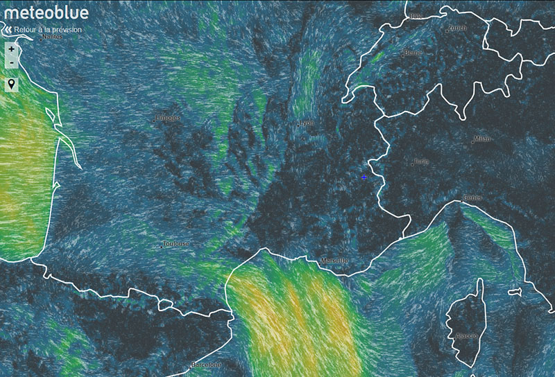
Forecasts and Observations Meteoblue
Very comprehensive forecast site with "radar precipitation" images coupled with satellite images in the visible field, map of the wind flow, ephemeris etc ... A cross on the map locates your place of research. The forecast page is very precise and exhaustive, between real observations and forecasts in more or less short time. 14-day weather and meteogram provide visual and useful information.
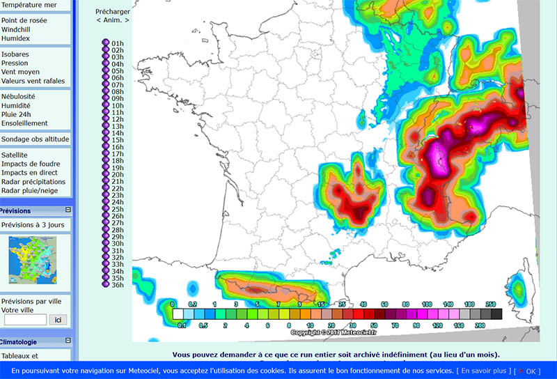
Forecasts and observation Meteociel
Site particularly complete. The temperature forecasts often seem to us too low of 3 to 4 ° Celsius. Many observation parameters: radar images precipitation rain and snow, pressure, wind dew point temperature etc. The main advantage of the site lies in the ability to compare the forecasts of different models, French but also foreign: Arome, Arpege, WRF, Alaro etc ... For each of these models it is possible to choose any kind of parameters: wind, temperature, humidity, pressure at different altitudes, precipitation etc ... and this for periods of several days ...

Forecasts and Observations Meteo60
A very precise precipitation radar map makes it possible to see the rain or the snow coming in almost directly (zoom possible). The infrared satellite map shows the altitude of the top of the cloud masses and can also see storms and cloudy fronts coming with great precision.

Romma.fr: Amateur and scientific networks of automatic observation stations in the Alps
Site essential and great because it allows to know the temperature, the wind and the actual humidity, measured scientifically, near you, updated live and continuously. These measures make it possible to see the arrival of a cold air mass or a significant wind reversal of a change in air mass, weather flow and therefore time.

Meteo France: Avalanche risk forecast Hautes Alpes
A bulletin offers for each massif of the High Alps (Pelvoux, Tabor, Champsaur, Devoluy, Embrunnais-Parpaillon, Queyras) the risk on a scale of 1 to 5 according to the altitudes and orientations of slope, evolutions, snow iso 0 ° etc. ... Essential before going out in the mountains during snowy periods ...

Radar precipitation Piedmont:
Allows from another angle, from Italy to have, a view of rainfall. The department of Hautes-Alpes is on the extreme left of the image.

Meteo France emagram
In addition to the traditional forecasts. Météo France offers meteorological experts the results of radiosonde balloon sounding which give all the vertical characteristics of the air mass (wind, temperature and humidity) measured twice a day at all altitudes. Request a minimum of technical skills for decrypt emagrams.

Radar precipitation from Switzerland
The radar overflows to the Hautes-Alpes recognizable thanks to the lake of Serre Ponçon. Do not forget that a precipitation radar does not see behind a first rain curtain hence the interest of having several angles of view, on this page links to an Italian radar to the east, a French to the south west and a Swiss to the north.

Webcams Hautes-Alpes
Many webcams dot the department to "see the weather arrive" and know for example what is the altitude of the rain snow limit. The departmental road service but also almost all ski resorts have webcams visible online.

Pollution observation in the Hautes-Alpes
Even if the air is pure, the sky is often blue and the pollution factors are less numerous than in the big cities, the Hautes Alpes receive either Italian industrial cities of the Po (Turin and Milan), or the valley of the Rhône from Lyon to Marseille, visible pollution on the linked page. Briançon, a climatic city particularly suitable for people suffering from respiratory disorders (asthma etc.), offers a very good air quality (very little wet), except exceptional episodes of overflow of urban pollution.

Alpine Pollen Maps
A pollen map that irritates more and more people over the years. Information from pollen sensors and medical consultations related to allergies. A newsletter informs you of the pollen species being traced.

Map of various epidemics
The sentinel network offers people with frail and compulsive hypochondriacs cards for the spread of influenza, gastroenteritis and chickenpox. Useful if you want to wash your hands even more often than usual!